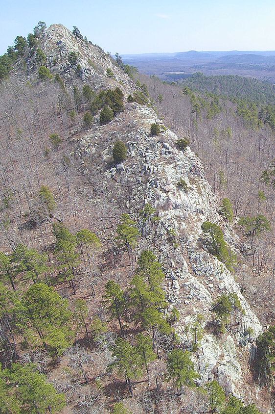
Located in Pulaski County, just west of Pinnacle Mountain State Park, Rattlesnake Ridge Natural Area protects rare plant and animal species, while offering visitors a rugged, low-impact recreational experience. The area provides habitat for three species of state conservation concern: the southeastern bat, the western diamondback rattlesnake, and Wright’s cliffbrake, a western desert fern. The ridge, Rattlesnake Ridge, is the watershed divide between the Big Maumelle and Little Maumelle rivers. It is comprised of a rare natural community, Ouachita Mountain Sandstone Outcrop Barrens, which is home to rare plants and animals typically found further west in hotter, drier places. The ridge, one of the most dramatic rocky summits in the eastern Ouachita Mountains, completes the northern boundary of the natural area. It is ¾ mile wide and rises up to 920 feet above sea level at its summit.
TRAIL
All of the trails in the Rattlesnake Ridge Trail System are open to hiking and biking. Trails vary in length and difficulty. The Trail System is currently
not ADA accessible.
Download Trail System Map
Please note that the gate to the natural area closes and locks at dusk, reopening the next morning. If you are locked behind the gate after dark, please call 501.371.9322. If the gate is locked during the day, the parking lot is full and we are managing traffic to keep visitors safe and practice social distancing during the COVID-19 pandemic. We appreciate your understanding and encourage you to wait until the lot is open or to visit again soon.
During times of wet weather, the natural area will be closed to protect the trails from damage. During these times, please call 501.663.6699 to check on the status.
DIRECTIONS
**Please use ANHC's written directions to verify directions provided by Google Maps. The Google Maps link may take you to a location other than the parking lot. The error has been reported to them. The correct GPS coordinates to the parking area are: 34.838225, -92.521126. The physical address is 9515 Barrett Rd., Roland, AR 72135.**
ANHC DIRECTIONS: From Little Rock (Junction of Interstate 430 and State Highway 10) head west on State Highway 10 for approximately 8.5 miles. Turn right onto Barrett Rd. and travel 1.2 miles. The natural area is on the left side of the road.
HUNTING
Hunting is prohibited on this natural area.
Related Content