Ecologists are always wishing they could go back in time and see how the landscape used to look and function. But until someone invents a time machine, we have to rely on the next best things — descriptive historical accounts, historical aerial photography (if we’re lucky, and only back to the 1930s in most areas), and the General Land Office (GLO) survey records. The GLO records are a wonderful resource for ecologists and historians because they provide both qualitative and quantitative descriptions of the landscape as far back as 200 years ago.
Collecting ecological data for scientists and land managers two centuries in the future probably wasn’t on the minds of the surveyors as they stretched their chains in the early 1800s, but they ended up doing just that. The practice of recording two to four “witness” trees at each section corner (usually one in each quadrant of the intersection between the two section lines) amounts to what ecologists call a “point quarter sample.” The data gathered by the surveyors to precisely mark (and be able to relocate) the section corners included the following: 1) the distance and compass bearing from the corner to the nearest witness tree in each quadrant, 2) the species of each witness tree, and 3) the diameter of each witness tree. These data can be analyzed quantitatively to understand important information about both the structure (density and size of trees) and species composition of wooded ecosystems.
Surveyors also described the character of the land every half mile, recording qualitative data on topography, soils, undergrowth, etc. These sorts of descriptions provide us with evidence that many upland habitats in the state were more open historically than they are today. For example, the GLO notes in some areas are filled with phrases like “grassy open woods,” “lacking in undergrowth save an abundance of grasses and flowers,” “glades this mile,” “land barren,” etc. In this regard, the GLO records also show us how much certain landscapes have changed in the last 200 years.
 GLO records can provide us with valuable insight when we undertake habitat restoration. Areas that were historically open savanna and woodland but are now dense forest (due to the suppression of fires across the landscape) can be thinned and burned as part of a restoration prescription Similarly, sites that were once open glades (rocky, naturally open grasslands) are very often solid stands of dense cedar growth today, and need to have the cedar removed as part of restoration (see Partnership Benefits Two Agencies: Restoration of Prairies and Glades for Fish and Anglers and Partnerships Grow, Improving Restoration Efforts and Fish Habitat ). The GLO records help guide us when we work to restore areas that were cleared of native vegetation in the past. For example, ANHC staff recently used GLO records to determine what tree species to use in reforestation efforts in old pastures at Devil’s Eyebrow and Foushee Cave natural areas.

Another area where GLO records provide essential insight is the mapping of historical grasslands. Native prairies are nearly gone from Arkansas but maps made by the GLO surveyors record where they were historically. The recent digitization of prairies mapped on GLO plat maps by Dr. John Barone of Columbus State University in Georgia has been a great tool for the ANHC research section. These maps help us locate not only where the prairies were, but where rare prairie species may still be hanging on.

Graphics:
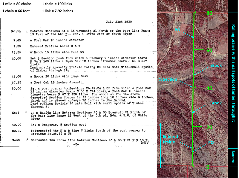
Graphic 1 — Overlay of 1830 GLO notes on a 2006 color-infrared aerial photograph of a 1-mile long section line in Marion County near the White River. In 1830 the landscape on this mile was described as "barrens" (savanna) and "rolling prairie with small spotts [sic] of timber through it." Today what isn't pasture is mostly forested in scrubby hardwood trees and dense stands of eastern red-cedar (showing red in the photo), but some pockets of open grassland remain.
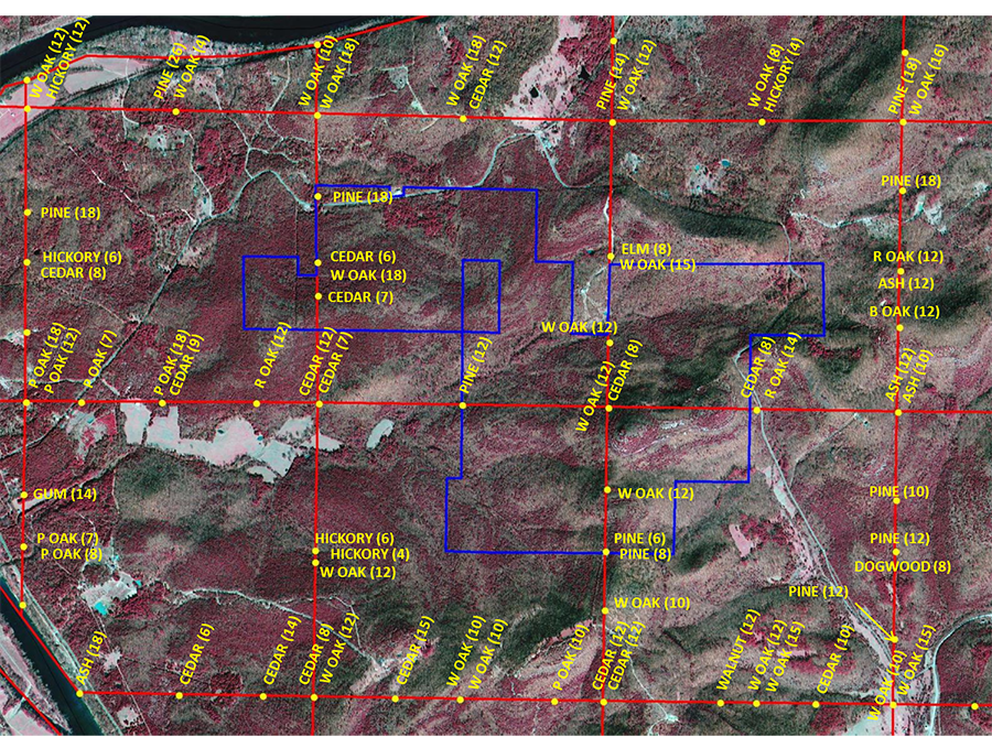
Main Graphic/Graphic 2 — A study of GLO records around Devil's Knob-Devil's Backbone Natural Area by ANHC Chief of Research Theo Witsell indicates that cedar encroachment in formerly open glade and woodland landscapes started at least as early as the mid- to late 1700s in that area. This graphic shows the natural area boundary (blue), the 1 mile by 1 mile GLO section grid (red), and the species and diameter (in inches) of line and witness trees (yellow) recorded in the original 1821 survey. Note the relative large size of cedars (9 inch diameter), pines (14.3 inch diameter), and ash (13 inch diameter). Based on growth rates we see on trees today, one hypothesis is that there was a reduction in fires in the landscape sometime in the mid- to late 1700s, perhaps coinciding with depopulation of Native Americans in the area.
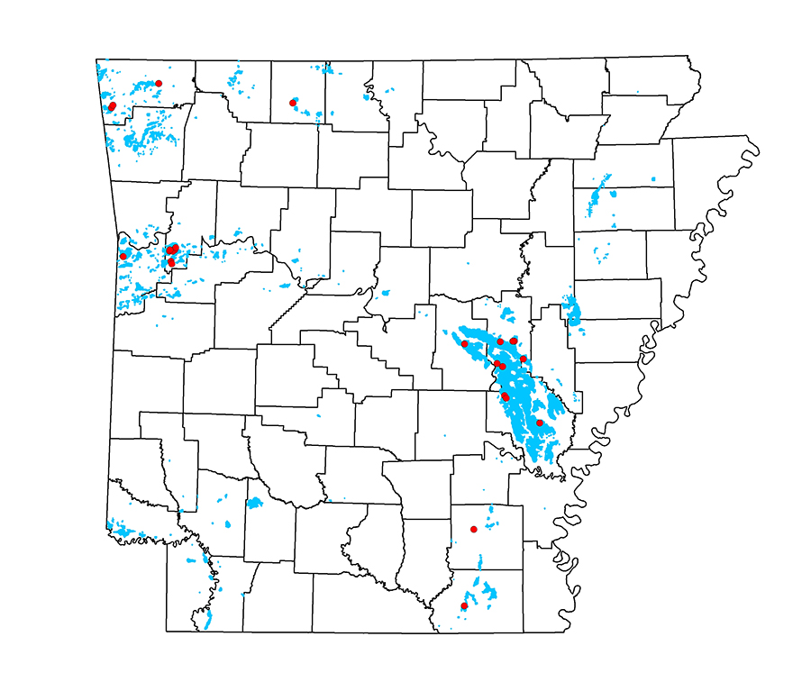
Graphic 3 — Map showing prairies mapped in the GLO survey (blue) and the known locations of Oklahoma grass-pink orchid (Calopogon oklahomensis). This rare species is found only in ancient prairie remnants and is known from no other habitat type in the state. Prairies mapped by Dr. John Barone, Columbus State University, from GLO plat maps.
Collecting ecological data for scientists and land managers two centuries in the future probably wasn’t on the minds of the surveyors as they stretched their chains in the early 1800s, but they ended up doing just that. The practice of recording two to four “witness” trees at each section corner (usually one in each quadrant of the intersection between the two section lines) amounts to what ecologists call a “point quarter sample.” The data gathered by the surveyors to precisely mark (and be able to relocate) the section corners included the following: 1) the distance and compass bearing from the corner to the nearest witness tree in each quadrant, 2) the species of each witness tree, and 3) the diameter of each witness tree. These data can be analyzed quantitatively to understand important information about both the structure (density and size of trees) and species composition of wooded ecosystems.
Surveyors also described the character of the land every half mile, recording qualitative data on topography, soils, undergrowth, etc. These sorts of descriptions provide us with evidence that many upland habitats in the state were more open historically than they are today. For example, the GLO notes in some areas are filled with phrases like “grassy open woods,” “lacking in undergrowth save an abundance of grasses and flowers,” “glades this mile,” “land barren,” etc. In this regard, the GLO records also show us how much certain landscapes have changed in the last 200 years.
 GLO records can provide us with valuable insight when we undertake habitat restoration. Areas that were historically open savanna and woodland but are now dense forest (due to the suppression of fires across the landscape) can be thinned and burned as part of a restoration prescription Similarly, sites that were once open glades (rocky, naturally open grasslands) are very often solid stands of dense cedar growth today, and need to have the cedar removed as part of restoration (see Partnership Benefits Two Agencies: Restoration of Prairies and Glades for Fish and Anglers and Partnerships Grow, Improving Restoration Efforts and Fish Habitat ). The GLO records help guide us when we work to restore areas that were cleared of native vegetation in the past. For example, ANHC staff recently used GLO records to determine what tree species to use in reforestation efforts in old pastures at Devil’s Eyebrow and Foushee Cave natural areas.
Another area where GLO records provide essential insight is the mapping of historical grasslands. Native prairies are nearly gone from Arkansas but maps made by the GLO surveyors record where they were historically. The recent digitization of prairies mapped on GLO plat maps by Dr. John Barone of Columbus State University in Georgia has been a great tool for the ANHC research section. These maps help us locate not only where the prairies were, but where rare prairie species may still be hanging on.

Graphics:
Graphic 1 — Overlay of 1830 GLO notes on a 2006 color-infrared aerial photograph of a 1-mile long section line in Marion County near the White River. In 1830 the landscape on this mile was described as "barrens" (savanna) and "rolling prairie with small spotts [sic] of timber through it." Today what isn't pasture is mostly forested in scrubby hardwood trees and dense stands of eastern red-cedar (showing red in the photo), but some pockets of open grassland remain.
Main Graphic/Graphic 2 — A study of GLO records around Devil's Knob-Devil's Backbone Natural Area by ANHC Chief of Research Theo Witsell indicates that cedar encroachment in formerly open glade and woodland landscapes started at least as early as the mid- to late 1700s in that area. This graphic shows the natural area boundary (blue), the 1 mile by 1 mile GLO section grid (red), and the species and diameter (in inches) of line and witness trees (yellow) recorded in the original 1821 survey. Note the relative large size of cedars (9 inch diameter), pines (14.3 inch diameter), and ash (13 inch diameter). Based on growth rates we see on trees today, one hypothesis is that there was a reduction in fires in the landscape sometime in the mid- to late 1700s, perhaps coinciding with depopulation of Native Americans in the area.
Graphic 3 — Map showing prairies mapped in the GLO survey (blue) and the known locations of Oklahoma grass-pink orchid (Calopogon oklahomensis). This rare species is found only in ancient prairie remnants and is known from no other habitat type in the state. Prairies mapped by Dr. John Barone, Columbus State University, from GLO plat maps.
