With more than 70,000 acres, the ANHC can’t know every inch of every natural area. Upon purchase, our natural area boundaries are documented, mapped, and marked. Our stewardship and research staff conduct surveys of the property, mainly looking for any plants or animals of conservation concern. In addition, information provided to us by former landowners or surveyors is included in the data that we maintain on each natural area. However, this still leaves the opportunity for new discoveries, whether plant, animal, natural community, or geologic feature.
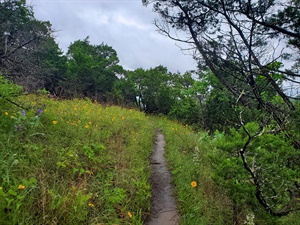
 ANHC Land Management Specialists Emily Roberts and Ryan Spotts were recently given a tip from ANHC Botanist Diana Soteropoulos about a possible undocumented cave located on Devil’s Knob-Devil’s Backbone Natural Area (NA) in Izard County. The next time Roberts and Spotts visited the area to perform trail maintenance, they were eager to check out the location of the “pit” that Soteropoulos had reported. (Photo at left -- Part of the trail at Devil's Knob-Devil's Backbone Natural Area, photo by Emily Roberts.)
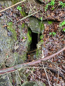
 The opening that Roberts and Spotts were searching for is tiny (see photo at left, by Emily Roberts), but with Soteropoulos’ directions, they located it. The “pit” only went down about 40 feet at a slant, classifying it as a cavelet. A cavelet is a small opening large enough for a human to enter, but too small to be classified as an actual cave. Cavelets are formed by the same natural geological processes as caves. Roberts was able to climb into the cavelet and explore it.
As a result of the ANHC’s partnership with the Cave Research Foundation (CRF), two other cavelets and a larger cave, Devil’s Knob Cave, have been located, surveyed, and mapped at Devil’s Knob-Devil’s Backbone NA. The ANHC has been partnering with the CRF since 2019 to study, protect and preserve cave resources and karst areas on our natural areas. CRF volunteers have provided ANHC staff with technical support, and training in mapping and biological inventories of karst features. Seven of the ANHC’s natural areas have known caves: Cave Springs Cave, Devil’s Eyebrow, Devil’s Knob-Devil’s Backbone, Foushee Cave, Garrett Hollow, Hell Creek, and Slippery Hollow.
The ANHC and CRF will continue to conduct biological inventories and map karst features on our natural areas. They also plan to co-host a volunteer cleanup event in the fall.
 ANHC Land Management Specialists Emily Roberts and Ryan Spotts were recently given a tip from ANHC Botanist Diana Soteropoulos about a possible undocumented cave located on Devil’s Knob-Devil’s Backbone Natural Area (NA) in Izard County. The next time Roberts and Spotts visited the area to perform trail maintenance, they were eager to check out the location of the “pit” that Soteropoulos had reported. (Photo at left -- Part of the trail at Devil's Knob-Devil's Backbone Natural Area, photo by Emily Roberts.)
 The opening that Roberts and Spotts were searching for is tiny (see photo at left, by Emily Roberts), but with Soteropoulos’ directions, they located it. The “pit” only went down about 40 feet at a slant, classifying it as a cavelet. A cavelet is a small opening large enough for a human to enter, but too small to be classified as an actual cave. Cavelets are formed by the same natural geological processes as caves. Roberts was able to climb into the cavelet and explore it.
 As a result of the ANHC’s partnership with the Cave Research Foundation (CRF), two other cavelets and a larger cave, Devil’s Knob Cave, have been located, surveyed, and mapped at Devil’s Knob-Devil’s Backbone NA. The ANHC has been partnering with the CRF since 2019 to study, protect and preserve cave resources and karst areas on our natural areas. CRF volunteers have provided ANHC staff with technical support, and training in mapping and biological inventories of karst features. Seven of the ANHC’s natural areas have known caves: Cave Springs Cave, Devil’s Eyebrow, Devil’s Knob-Devil’s Backbone, Foushee Cave, Garrett Hollow, Hell Creek, and Slippery Hollow.
The ANHC and CRF will continue to conduct biological inventories and map karst features on our natural areas. They also plan to co-host a volunteer cleanup event in the fall.
