Listed in Arkansas Register of Historic Places on 12/02/20
SUMMARY
The Zero Milestone is being nominated to the Arkansas Register of Historic Places under Criterion A with statewide significance for its association with the transportation history of Arkansas. Prior to the installation and designation of a zero milestone, there was no uniformity in determining highway distances across the state from Little Rock. The installation of the Zero Milestone in 1932 and its official designation in 1933, allowed for consistent measuring of highway distances across the state, a simple yet important advancement in the state’s highway history. After its designation as the Zero Milestone, all highway distances from Little Rock were measured from its location. Originally located in front of the State Capitol building, the Zero Milestone was moved to its current location in 2009. As a result, it is also being nominated to the Arkansas Register under Criteria Consideration B as a property that has been moved from its original location.
HISTORY OF THE PROPERTY
The early nineteenth century brought about the beginnings of early road development in Arkansas. Roads were developed as people migrated into the state and they were also developed for military purposes. Some of the first roads developed in Arkansas included the Southwest Trail, John Pyeatt’s Road, the East-West Military Road, and the first Post Road. The Southwest Trail began as a Native American Trail that Congress declared a military road in 1803, which brought about the appropriation of funds for its improvement. John Pyeatt’s Road came about around 1807, and connected Cadron with Crystal Hill and Arkansas Post, while the East-West Military Road connected Memphis to Little Rock and Fort Smith and was completed in 1828. The state’s first Post Road connected Batesville with Lewisburg on the Arkansas River just south of Morrilton, and it was developed shortly after statehood in 1836.[1]
Although the development of railroads during the mid-1800s made travel in parts of the state faster and easier, the majority of transportation was still done by way of horses and buggies. However, by the 1870s bicycles were increasing in popularity as a mode of transportation, especially in cities, since they were cheaper to buy and maintain. One other result of the increase in the popularity of bicycles was the establishment of “good roads” committees to push for the improvement of roads for easier and more comfortable riding.[2]
Although bicycling was not as popular in Arkansas as it was in other states, a group in Little Rock took the lead on advocating for good roads and persuaded Governor James P. Clarke to host a Good Roads Convention in Little Rock in February 1896. The convention ultimately led to the creation of “The Good Roads League of the State of Arkansas” which had five main goals, which were:
- To stimulate general interest in improved public roads;
- To collect and disseminate better methods of road building and maintenance;
- To encourage state and federal legislation favoring road improvements, especially farm-to-market roads;
- To publish material necessary and useful in promoting the movement; and
- To promote the formation of a five-member committee in each county to organize and promote local activities for road improvements.[3]
Although some laws were passed regarding road building in the late nineteenth and early twentieth centuries, including the Prince Act of 1897 and the Arnold Road Bill of 1907, the majority of road building efforts and, more importantly, funding was a county responsibility.[4] The transformation of road building to a state-wide effort really got a boost with Act 302 of 1913 which established the State Highway Commission. The Commission consisted of three members – the Commissioner of State Lands, Highways, and Improvements, along with two other members appointed by the Governor who served staggered two-year terms.[5]
Act 302 also defined the responsibilities of the Department of State Lands, Highways, and Improvements as “the general supervision over road construction and maintenance; furnishing counties and improvement districts with advice and assistance; preparing and distributing information relative to roads, bridges, drainage levees, and other public improvements; distributing available funds for the construction of public roads; overseeing the efficient utilization of county and state convicts; and promoting greater interest in the improvement of Arkansas’s highways.” The Act also established the first Highway Improvement Fund that was funded by an annual $10 license fee on motor vehicles.[6] Arkansas now had the tools and mechanisms in place to seriously pursue the construction of an improved highway system.
An improved highway system would have been an important link in the state’s transportation infrastructure, especially given the increase in automobile and truck traffic that used the state’s roads during the 1920s. Once the automobile came to Arkansas, it grew quickly in acceptance. By 1915, there were 8,010 automobiles registered in the state, and the tremendous growth in the automobile’s popularity continued into the 1920s.[7] According to the Sixth Biennial Report of State Lands, Highways and Improvements, the number of cars licensed in the state grew from 102,065 in 1923 to 123,456 in 1924 and the number of trucks licensed in the state grew from 11,131 in 1923 to 16,280 in 1924. The dramatic increase in the number of cars and trucks on the road during the 1920s necessitated a lot of improved highway infrastructure, including roads and bridges.[8]
The increased use of the automobile in Arkansas not only allowed people to travel for necessity, but it also brought about the use of the automobile for leisure travel. The 1910s through the 1930s was a period in which auto tourism really began to become a popular pastime. As has been noted, automobile tourism’s “Flexibility of action enabled motorists to linger and see the places through which they passed, and they could see new places off the beaten track of railroad travel.”[9] In addition, there were several organizations that helped to foster tourism. The best known of these organizations was the American Automobile Association, known as AAA, which was founded in Chicago on March 4, 1902, and provided motorists with what were called AAA bluebooks, which contained “detailed route descriptions, maps, and lists of garages and hotel accommodations…”[10] AAA, with the help of Boston telephone pioneer Charles J. Glidden, also organized the Glidden Tours between 1905 and 1913, which were designed to show the practicality of interstate highways and the usefulness of the automobile as a means of long-distance transportation.[11] However, other organizations and resources existed, such as the Automobile Legal Association in the northeastern United States that published the Automobile Green Book, which was a “road reference and tourists’ guide.”[12] Of course, for African Americans, The Negro Motorist Green Book became an invaluable resource for automobile travel beginning in the 1930s.
In Arkansas, state resources also existed that could help tourists plan trips. The Arkansas State Highway Commission published tourist maps of state highways beginning in 1916, which was an invaluable resource to motorists. Furthermore, the state’s Biennial Reports provided information on highway projects that had been completed around the state in the past two years.[13]
In addition, the guide to Arkansas published as part of the WPA’s American Guide Series fostered automobile tourism in its own way, and noted in 1941 that “Today the Arkansas highway system compares well with that of other states. Concrete highways run from Memphis to Fort Smith, and from Missouri to the Texas border. Other major roads are integrated into a plan, are graveled or paved with blacktop, and maintained in good condition.”[14] The roads allowed motorists to go to “countless vacation spots in the State and national parks and the national forests.”[15]
However, it was not just the pavement, bridges, and other infrastructure that needed to be upgraded and improved in order to have a useful highway system. There had to be a way to designate the highways, especially in rural areas, much like streets were named in cities and towns. By the 1920s, Arkansas initially started designating highways with alpha-numeric route designations, that included “A,” “B,” and “C” roads. “A”-series roads were Primary Federal Aid Roads while “B”-series roads were Secondary Federal Aid Roads and “C”-series roads were Connecting State Roads. However, there did not seem to be any rhyme or reason to how the numbers were assigned to the roads.[16]
Although Arkansas had a numbering system in place by the early 1920s, it was a couple of years before a national numbering system was considered and put in place. The American Association of State Highway Officials (AASHO) asked for a committee of state and federal highway officials to be appointed to come up with a new system of designating highways, and they agreed at their first meeting in April 1925 to number highways rather than name them. After getting input during May and June 1925 on what highways should be included in the new national system, the committee agreed in August 1925 on a system of 50,100 miles of roads.[17]
The next task was to come up with a system to use to number the highways. As Earl Swift writes in his book, The Big Roads: The Untold Story of the Engineers, Visionaries, and Trailblazers Who Created the American Superhighways:
The assignment was a tough one. Numbers would have to be user-friendly, instinctively sound, and flexible enough to permit future additions to the grid.
…
…The numbering would be lowest in both directions in the northeast corner of the country, up at Maine’s border with Canada, and would climb as one moved south and west – in other words, the east-west highways with the lowest numbers would run through the nation’s northernmost states, and those with the highest, along the Gulf Coast and Mexican border; north-south highways would bear the lowest numbers on the Atlantic coast and the highest on the Pacific.
One- or two-digit numbers would denote principal highways. A three-digit number would mark a spur or variant of a main route and would connect with the parent road at some point. The arrangement created a simple geographic weave. …
…The most important of the east-west routes, including all the transcontinental highways, would have numbers ending in zero – 10, 20, 30, 40, and so on. The most important north-south highways would end in 1.[18]
Nationally, by the late 1920s, U.S. highway numbers ranged from U.S. 1, which connected Fort Kent, Maine, with Miami, Florida, up to U.S. 830, which connected U.S. 101 northeast of Ilwaco, Washington, to U.S. 97 north of Maryhill, Washington.[19]
Although the change to a numerical system of road designation may have been less romantic to the traveling public than named roads such as the Dixie Highway, Jefferson Highway, Lincoln Highway, or the William Penn Highway, it was generally accepted. However, an editorial in the New York Times in the 1920s did note that, “The traveler may shed tears as he drives the Lincoln Highway or dream dreams as he speeds over the Jefferson Highway, but how can he get a ‘kick’ out of 46 or 55 or 33 or 21! The roads of America would still be on paper if the pleas that were made ten years ago had been made on behalf of a numerical code.”[20]
Once a highway system was under development, one issue that had to be addressed was measuring mileage on the system. Since it was a national highway system, it needed to be a mileage system that would be consistent nationwide. The need for a consistent way to measure mileage on the U.S. highway system led to the establishment of a national Zero Milestone in 1919.
The idea of measuring distances on roads in the United States dates to at least the eighteenth century when Benjamin Franklin was postmaster. In order to calculate postal rates, which at the time were based on the distance that a piece of mail was carried, it became necessary to be able to determine distances on the Boston Post Road. To solve the problem, Franklin devised an odometer that was able to measure distances along the route. Mile markers were then erected along the road, not only to help calculate postal rates, but also to guide riders along the road between New York and Boston.[21]
The concept of measuring mileage on highways also became a concern during the early twentieth century as automobiles became more prevalent, and it was good roads advocates that pushed for the idea of a zero milestone, or a spot from which all highway mileages could be measured. Ultimately, it was good roads advocate Dr. S. M. Johnson who submitted a proposal to Colonel J. M. Ritchie of the U.S. Army’s Transportation Corps on June 7, 1919, for a zero milestone. He wrote:
It seems to me the time has come when the Government should designate a point at which the road system of the United States takes its beginning, and that spot should be marked by an initial milestone, from which all road distances in the United States and throughout the Western hemisphere should be reckoned.
Rome marked the beginning of her system of highways which bound her widely scattered people together by a golden milestone in the Forum. The system of highways radiating from Washington to all the boundaries of the national domain and all parts of the Western hemisphere will do vastly more for national unity and for human unity than even the roads of the Roman Empire…
This stone will endure as the generations and the centuries come and go, till time shall be no more. If that golden milestone in Rome still has the power to fire the imagination of men, how much greater will be the appeal of the Washington milestone as time goes on and American history grows ever richer in deeds of service to humanity.[22]
Johnson also thought that the Zero Milestone would be a good location for the start of the motor convoy that the U.S. Army was going to soon be sending across the country.
The proposal that Johnson submitted to Ritchie was forwarded to Secretary of War Newton D. Baker, who approved the proposal for a Zero Milestone, but it was up to Johnson to provide the Milestone. Johnson learned that an Act of Congress would be needed in order to erect the Milestone in the District of Columbia, but due to the fact that the motor convoy would be leaving on July 7th, Johnson initially received a permit for a temporary milestone from the Officer in Charge of Public Buildings and Grounds. Once the Act of Congress was passed, a permanent Zero Milestone could then be erected.[23]
The temporary Zero Milestone was provided by Mrs. F. W. Hockaday of Wichita, Kansas, who was the president of the National Highway Marking Association. The Milestone was dedicated on July 7, 1919, before the Army’s motor convoy set out for California, and the dedication was described in Peter Davies book, American Road: The Story of an Epic Transcontinental Journey at the Dawn of the Motor Age. Davies wrote:
Before this spectacular assembly could get on the long road to the Pacific, however, they had to be formally sent off. They first had to dedicate the Zero Milestone.
…Waiting for them before a speaker’s podium beneath an arc of trees, an assembly of notables and high-ranking officers gathered around a stumpy object sheathed in a white sheet.
Chief among them was Secretary of War Newton Baker, a small, bespectacled man in a white linen suit. Assorted senators and congressmen were present, as was General Peyton March, the chief of staff, heading a medaled array of military men, and Brigadier General Charles B. Drake, the chief of the Motor Transport Corps…
…
Unveiled from its white wrapping, the Zero Milestone was presented to the secretary of war.[24]
The process to gain approval for the permanent Zero Milestone began shortly after the dedication of the temporary marker. Johnson drafted a bill for the permanent marker, and after getting endorsements from Secretary Baker, the U.S. Bureau of Public Roads, the American Automobile Association, and the National Automobile Chamber of Commerce, Congressman Julius Kahn of California introduced the bill on January 5, 1920. The bill for the permanent Zero Milestone was approved on June 5, 1920, and required that the design of the marker be approved by the Fine Arts Commission. It also required that the marker not cost the Federal government any money.[25]
Dr. Johnson was put in charge of the details for the Milestone, and he hired Washington, D.C., architect Horace W. Peaslee to design the Milestone and supervise its erection. Johnson also raised funds for the monument, and contributions came from a combination of private individuals and corporations, including Durant Motors Company, Packard Motor Company, General Motors Corporation, and the American Automobile Association. The permanent Zero Milestone was dedicated on June 4, 1923, in a ceremony that was attended by President Warren Harding, Secretary of Agriculture Henry C. Wallace, U.S. Bureau of Public Roads Chief Thomas H. MacDonald, and representatives of the auto industry.[26]
Once the national Zero Milestone was dedicated advocates tried to spread the idea of zero milestones to other parts of the country. In fact, the AAA explained in its October 1923 issue of American Motorist magazine that:
Motorists are familiar with the conflicting statements of roadside markers as to the distance to or from a certain city or town, all because the mileage was measured from different points. … With official milestones in each city and town, all disputes as to distances between certain cities or towns can be accurately settled as the understanding will be that the distances between milestones will be taken.[27]
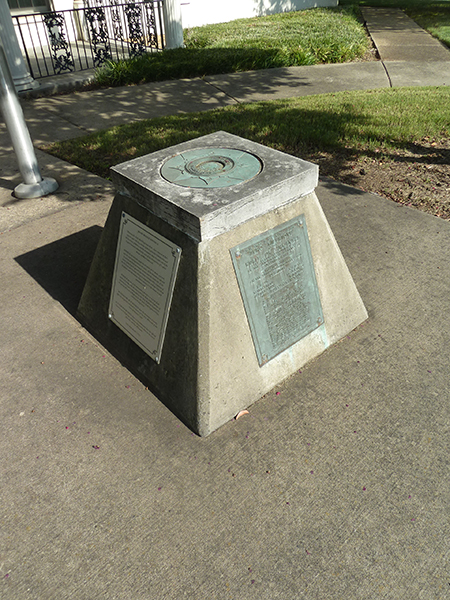
Although there were other zero milestones dedicated around the country during the 1920s, including in San Francisco, California: Nashville, Tennessee; and Richmond, Virginia, Arkansas did not explore the idea until the early 1930s. In the early 1930s, the Little Rock Engineers Club formed a committee to erect a zero milestone in Arkansas. The committee was chaired by George C. Branner, head of the Geological Survey of Arkansas, and its other members included M. Z. Bair, R. A. Kern, W. Terry Feild, Virgil P. Knott, C. S. Christian, and W. H. Marak. The state’s Zero Milestone was ultimately placed in front of the Capitol in 1932. The Zero Milestone’s location was described in 1934 as being:
At east edge of capitol grounds in Little Rock, 3 feet east of east edge of flower garden, in front of main entrance to capitol, about 34.5 feet west of intersection of center line of West Capitol Avenue and cement curb at east-central entrance to capitol grounds, and about 14.75 feet from top of flight of steps leading from street to pavement which connects front steps of capitol.[28]
Even though the Zero Milestone was put in place in 1932, it was not officially designated as the Zero Milestone until 1933 with the passage of Senate Resolution No. 23 on March 7, 1933, which said, in part:
WHEREAS, the use of the monument referred to as a point from which to determine the distance from Little Rock on the highways of Arkansas has been recommended by the Chief Highway Engineer; by the present Director of Highways, by the Little Rock Engineer’s Club, and by local engineers;
NOW THEREFORE, BE IT RESOLVED that this monument is hereby officially recognized and shall be known as “the Zero Milestone of the State of Arkansas”; and
BE IT FURTHER RESOLVED that it is recommended that the official distances on the highways of Arkansas from Little Rock be measured from the said Zero Milestone.[29]
After the official designation of the Zero Milestone by the Senate in 1933, a plaque, designed by Ted Owens Medearis in 1934, was added to the Milestone. The Zero Milestone remained at the Capitol until 2004 when it was removed. However, a project involving the Arkansas Board of Registration for Professional Engineers and Land Surveyors, Arkansas Secretary of State Charlie Daniels, NOAA/National Geodetic Survey, Pulaski County Surveyor’s Office, Little Rock Engineers Club, Arkansas Society of Professional Surveyors, and the Arkansas Society of Professional Engineers relocated and rededicated the Zero Milestone on June 16, 2009, when it was placed in front of the offices of the Arkansas Board of Licensure for Professional Engineers and Professional Surveyors.
SIGNIFICANCE OF THE PROPERTY
During the early twentieth century, as the automobile became more prevalent in Arkansas, it was important to have the infrastructure to accommodate its use. One of the most important needs for automobiles (and trucks) was an upgraded highway system. Once the automobile came to Arkansas, it grew quickly in acceptance. By 1915, there were 8,010 automobiles registered in the state, and the tremendous growth in the automobile’s popularity continued into the 1920s, reaching over 120,000 cars by 1924.[30] Due to the dramatic increase in the number of cars and trucks on the roads during the 1920s, it necessitated a lot of improved highway infrastructure, including roads and bridges.[31]
However, one other issue with early highways in Arkansas – and in other parts of the country, at least initially – was that there was no consistent way to measure distances. Distances from one city to another may have been measured from different points in each city. The dedication of the temporary national Zero Milestone in 1919 and the permanent Zero Milestone in 1923 at least solved the problem on the national level. However, it would still have been an issue in Arkansas. Prior to the installation and designation of a zero milestone, there was no uniformity in determining highway distances across the state from Little Rock.
The installation of the Zero Milestone in 1932 and its official designation in 1933, allowed for consistent measuring of highway distances across the state, a simple yet important advancement in the state’s highway history. After its designation as the Zero Milestone, all highway distances from Little Rock were measured from its location in front of the State Capitol. Due to its importance in the transportation history of Arkansas, the Zero Milestone is being nominated to the Arkansas Register of Historic Places under Criterion A with statewide significance. Originally located in front of the State Capitol building, the Zero Milestone was moved to its current location in 2009. As a result, it is also being nominated to the Arkansas Register under Criteria Consideration B as a property that has been moved from its original location.
BIBLIOGRAPHY
Arkansas State Highway Department. Map of State of Arkansas Showing System of Primary and Secondary Federal Aid Roads and Connecting State Roads and Progress of Improvements. Little Rock: Arkansas State Highway Department, 1924.
Arkansas State Highway and Transportation Department. Historical Review Arkansas State Highway Commission and Arkansas State Highway and Transportation Department: 1913-1992. Little Rock: Arkansas State Highway and Transportation Department, 1992.
Automobile Legal Association (ALA). Automobile Green Book, Vol. One. Boston: Scarborough Motor Guide Company, 1928.
Automobile Legal Association (ALA). Automobile Green Book. Boston: Scarborough Motor Guide Company, 1933.
Cothren, Zac. “United States Highway 61 Arch, Blytheville vicinity, Mississippi County, Arkansas.” National Register of Historic Places Registration Form. In the files of the Arkansas Historic Preservation Program, 2001.
Davies, Pete. American Road: The Story of an Epic Transcontinental Journey at the Dawn of the Motor Age. New York: Henry Holt and Company, 2002.
Information on the Zero Milestone from plaques affixed to the Zero Milestone’s base, located at 623 Woodlane Street.
Ingram, Tammy. Dixie Highway, Road Building and the Making of the Modern South, 1900-1930. Chapel Hill: The University of North Carolina Press, 2014.
Jaffe, Eric. The King’s Best Highway: The Lost History of the Boston Post Road, the Route that Made America. New York: Scribner, 2010.
Jakle, John A. The Tourist: Travel in Twentieth-Century North America. Lincoln: University of Nebraska Press, 1985.
Sixth Biennial Report of the Department of State Lands, Highways and Improvements. Conway, AR: Conway Printing Company, c.1924.
State Highway Department. State of Arkansas Showing System of State Highways. Map. Little Rock: State Highway Commission, 1926.
Sutherland, O. P. U.S. Department of Commerce Coast and Geodetic Survey Special Publication No. 179: First-Order Triangulation in Kansas (1927 Datum). Washington, DC: United States Government Printing Office, 1934.
Swift, Earl. The Big Roads: The Untold Story of the Engineers, Visionaries, and Trailblazers Who Created the American Superhighways. Boston: Mariner Books, 2011.
Weingroff, Richard F. “Zero Milestone – Washington, DC.” Found at: https://www.fhwa.dot.gov/infrastructure/zero.cfm.
[1] Arkansas State Highway and Transportation Department. Historical Review Arkansas State Highway Commission and Arkansas State Highway and Transportation Department: 1913-1992. Little Rock: Arkansas State Highway and Transportation Department, 1992, pp. 5-8.
[2] Arkansas State Highway and Transportation Department. Historical Review Arkansas State Highway Commission and Arkansas State Highway and Transportation Department: 1913-1992. Little Rock: Arkansas State Highway and Transportation Department, 1992, pp. 9-10.
[3] Arkansas State Highway and Transportation Department. Historical Review Arkansas State Highway Commission and Arkansas State Highway and Transportation Department: 1913-1992. Little Rock: Arkansas State Highway and Transportation Department, 1992, p. 11.
[4] Arkansas State Highway and Transportation Department. Historical Review Arkansas State Highway Commission and Arkansas State Highway and Transportation Department: 1913-1992. Little Rock: Arkansas State Highway and Transportation Department, 1992, pp. 12-15.
[5] Arkansas State Highway and Transportation Department. Historical Review Arkansas State Highway Commission and Arkansas State Highway and Transportation Department: 1913-1992. Little Rock: Arkansas State Highway and Transportation Department, 1992, p. 20.
[6] Arkansas State Highway and Transportation Department. Historical Review Arkansas State Highway Commission and Arkansas State Highway and Transportation Department: 1913-1992. Little Rock: Arkansas State Highway and Transportation Department, 1992, p. 21.
[7] Cothren, Zac. “United States Highway 61 Arch, Blytheville vicinity, Mississippi County, Arkansas.” National Register of Historic Places Registration Form. In the files of the Arkansas Historic Preservation Program, 2001.
[8] Sixth Biennial Report of the Department of State Lands, Highways and Improvements. Conway, AR: Conway Printing Company, c.1924, pp. 197-205.
[9]Jakle, John A. The Tourist: Travel in Twentieth-Century North America. Lincoln: University of Nebraska Press, 1985, pp. 103-104.
[10] Jakle, John A. The Tourist: Travel in Twentieth-Century North America. Lincoln: University of Nebraska Press, 1985, p. 110.
[11] Ingram, Tammy. Dixie Highway, Toad Building and the Making of the Modern South, 1900-1930. Chapel Hill: The University of North Carolina Press, 2014, pp. 38-39.
[12] Automobile Legal Association (ALA). Automobile Green Book, Vol. One. Boston: Scarborough Motor Guide Company, 1928, and Automobile Legal Association (ALA). Automobile Green Book. Boston: Scarborough Motor Guide Company, 1933.
[13] Information on Arkansas State Highway Maps and Biennial Reports found at: www.ardot.gov/publications.aspx.
[14] West, Elliot. The WPA Guide to 1930s Arkansas. Lawrence, KS: University Press of Kansas, 1987 reprint of 1941 publication, pp. 56-57.
[15] West, Elliot. The WPA Guide to 1930s Arkansas. Lawrence, KS: University Press of Kansas, 1987 reprint of 1941 publication, p. 81.
[16] Arkansas State Highway Department. Map of State of Arkansas Showing System of Primary and Secondary Federal Aid Roads and Connecting State Roads and Progress of Improvements. Little Rock: Arkansas State Highway Department, 1924.
[17] Swift, Earl. The Big Roads: The Untold Story of the Engineers, Visionaries, and Trailblazers Who Created the American Superhighways. Boston: Mariner Books, 2011, p. 94.
[18] Swift, Earl. The Big Roads: The Untold Story of the Engineers, Visionaries, and Trailblazers Who Created the American Superhighways. Boston: Mariner Books, 2011, pp. 94-96.
[19] Today, the highest U.S. highway number is U.S. 730, which connects I-84 and U.S. 30 east of Boardman, Oregon, to U.S. 12 south of Wallula, Washington. U.S. 830 was removed from the system in 1968.
[20] Jakle, John A. The Tourist: Travel in Twentieth-Century North America. Lincoln: University of Nebraska Press, 1985, p. 125.
[21] Jaffe, Eric. The King’s Best Highway: The Lost History of the Boston Post Road, the Route That Made America. New York: Scribner, 2010, p. 42.
[22] Weingroff, Richard F. “Zero Milestone – Washington, DC.” Found at: https://www.fhwa.dot.gov/infrastructure/zero.cfm.
[23] Weingroff, Richard F. “Zero Milestone – Washington, DC.” Found at: https://www.fhwa.dot.gov/infrastructure/zero.cfm.
[24] Davies, Pete. American Road: The Story of an Epic Transcontinental Journey at the Dawn of the Motor Age. New York: Henry Holt and Company, 2002, pp. 7-8.
[25] Weingroff, Richard F. “Zero Milestone – Washington, DC.” Found at: https://www.fhwa.dot.gov/infrastructure/zero.cfm.
[26] Weingroff, Richard F. “Zero Milestone – Washington, DC.” Found at: https://www.fhwa.dot.gov/infrastructure/zero.cfm.
[27] Weingroff, Richard F. “Zero Milestone – Washington, DC.” Found at: https://www.fhwa.dot.gov/infrastructure/zero.cfm.
[28] Sutherland, O. P. U.S. Department of Commerce Coast and Geodetic Survey Special Publication No. 179: First-Order Triangulation in Kansas (1927 Datum). Washington, DC: United States Government Printing Office, 1934, p.46.
[29] Information on the Zero Milestone from plaques affixed to the Zero Milestone’s base, located at 623 Woodlane Street.
[30] Cothren, Zac. “United States Highway 61 Arch, Blytheville vicinity, Mississippi County, Arkansas.” National Register of Historic Places Registration Form. In the files of the Arkansas Historic Preservation Program, 2001.
[31] Sixth Biennial Report of the Department of State Lands, Highways and Improvements. Conway, AR: Conway Printing Company, c.1924, pp. 197-205.