Listed in Arkansas Register of Historic Places on 04/05/23
Summary Paragraph
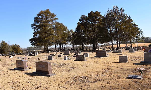
Pleasant Grove Cemetery is the resting place of residents of the unincorporated town of Scotland and the adjacent community of Pleasant Grove. In the mid-19th century, the area began to experience growth and development, but by the 1940s several factors contributed to loss of population and stagnation in commercial progress. Today, Scotland and Pleasant Grove are rural farming communities. Descendants of original settlers buried at Pleasant Grove Cemetery still reside in this area of the county.
Leventine A. and Mary Jane Plummer deeded 4.1 acres to the Pleasant Grove Society in 1876 for the use of the Methodist Episcopal Church South. Their children, H.L. and M.J. were buried on the grounds that became the Pleasant Grove Cemetery. There are no birth and death dates recorded for the children, so the burial of Joseph Newton Millsaps (1871-1871) is the earliest marked burial. However, his gravestone is a modern laser-etched granite ground marker. This might indicate a cenotaph or replacement for an uninscribed stone.
There are ongoing modern burials at Pleasant Grove Cemetery and several historic graves are marked with modern replacement stones. For these reasons Pleasant Grove Cemetery is being nominated to the Arkansas Register of Historic Places under Criteria A, Criterion Consideration D with local significance as a historic resource that conveys the early history of communities in Craig Township like Scotland, Pleasant Grove, Claude, Beverage Town, Gladys and the contributions of those residents to the political formation of Van Buren County. Period of significance is 1871-1960.
Narrative Statement of Significance
Van Buren County was formed from the surrounding counties of Conway, Independence, and Izard and took its final form in the 1880s. Initially, there was not much movement to this area of Van Buren County because of the rough terrain, making farming difficult. Also, it was not accessible by multiple convenient transportation routes, so immigrants circumvented the hill country.[1]
Earliest influx to the area south of the Little Red River began in the 1820s, but the wave of settlement increased after statehood in 1836 and the financial panic of 1837. A lengthy depression following the collapse of banks, low currency values and high prices caused many farmers to lose their land. As a result, families headed west. In the 1830s migrants to Van Buren County took on the job of clearing land to start over on small farms.[2]
In the early 19th century western Van Buren County in the vicinity of Scotland was a sparsely settled area of scattered farms. The hill country of modern Ozark National Forest was a
few miles to the west. Clusters of farms sprang up in western Van Buren County in areas locally referred to as settlements rather than towns. Mid-20th century census enumeration maps and highway maps note the existence of such settlements south and north of Scotland, known as Beverage Town, Claude, Walnut Grove, Gladys, and Pleasant Grove.[3]
There was a post office in a home on the Clinton-Dover Road but in 1874 it was moved to a store in what became Scotland when the post office was officially established under that name. Prior to that, modern-day Scotland was included as a settlement within an area known as “the Gulf.” The area was adjacent to Gulf Mountain in Craig Township, which was designated in 1842. Part of Craig was transferred to Culpepper and Mountain Townships between 1890 and 1900. Settlements in the western section of Van Buren County slowly became more defined with permanent structures and social and cultural institutions. There were few roads through the county, but the Bell Route of the Trail of Tears was just south, which historically provided access east and west. The road from Clinton to Dover, which predated Arkansas Highway 95 spanned northeast from Fort Smith through Van Buren County, so despite the rough terrain these routes made it somewhat easier for settlers to establish farms in what would become known as Scotland.[4]
In 1876 Leventine Plummer and his wife Mary Jane purchased 160 acres of land at the intersection of modern Arkansas Highway 95 and Pleasant Grove Loop. In that year the Plummers deeded 4.1 acres for the use of the Methodist Episcopal Church. In 1880 a two-story church was built adjacent to the cemetery. The structure was destroyed in 1933 and replaced with a one-story church. This building was altered in the 20th and 21st centuries, but it still stands on the location. Oral history states that the Plummer’s children M.J. and H.L. Plummer (ND) were the first interments on the site of the Pleasant Grove Cemetery. Their modern granite gravestones do not include birth and death dates, and the earliest marked death date is that of Joseph Newton Millsaps (1871-1871). His grave is marked with a modern granite stone as well.[5]
Settlers were noted in the area by 1849, but homes were not concentrated in one area, rather they were few and far between. The Civil War caused disruptions in growth, but post-war development experienced a slow trajectory. The first general store in Scotland was said to have been built in 1877 and was likely the site of the post office as the proprietor, James Daniel Blue
was the postmaster. The population of Scotland in 1880 was only 25, but it became a commercial and educational center for residents spread out in adjacent communities.[6]
The first recorded religious and educational institution was noted as being located one-half mile east of Scotland. The building served the dual purpose of church and school. The first school for Scotland proper was held in the N.A. Simpson Store on the community’s main street, which is now known as Arkansas Highway 389. In 1887 a third school was constructed, and in 1890 the Scotland Male and Female Academy was built. The numbers of students at the academy grew to a point where a larger school was required and in 1926 the Scotland School was dedicated but closed in circa 2004. (AR 12/06/00).[7]
Between 1840 and 1910 there was an increase of 11,999 people to the county. In 1910 the Missouri and North Arkansas Railroad (M&NA) constructed a depot at Shirley, northeast of Scotland. Railroad access led to commercial growth as goods and services were introduced to the area and the timber industry experienced a boost. By 1916 Scotland had an expanding sector of seven stores including two drug stores, three soda fountains and a grocery store. Eventually, there was a bank, blacksmiths, barber shops, shoe and harness shops, grist mills, a cotton gin and three hotels.[8]
The 1920s saw a more diverse economy emerge. A test well was drilled in Pleasant Grove by the Eagle Oil and Gas Company in 1922. The well did not produce and it was the only well to be drilled in the vicinity. A broom factory, sawmill, stave mill and garage for the increasing numbers of cars were added to the commercial corridor of Scotland. This fed the upward arc of population growth countywide; however, by 1940 the numbers began to decline.[9]
The decrease in population was the result of farmers feeling the effects of economic downturns. Farming techniques changed, necessitating expensive chemicals for optimum yields, and cotton demand fell so agriculturalists had to move to support their families. World War II introduced defense industry jobs in other states. Local veterans left the county after the war for new job opportunities and to join family that had previously moved. The timber industry in the county declined in 1949 because of overcutting, which led to the closure of the M&NA line, compounding the outflux of residents.[10]
The Little Red River was dammed by 1962, which created Greers Ferry Lake. The formation of the lake contributed to mid-century changes in Van Buren County, because it covered former farmland, and the communities of Choctaw and Eglantine. It also became a tourist attraction, which resulted in housing developments like Fairfield Bay. The development was located mostly in Van Buren County on the north shore of the lake by 1966, so growth was concentrated
primarily to the east of Scotland and Pleasant Grove. The land in the Ozark National Forest, established in 1908, was shielded from development, further keeping population numbers down in that area.[11]
From the early 19th-to mid-20th century Scotland had essentially experienced the upward growth of a new settlement and subsequently a downward arc due to cultural and social events. Today, the former commercial center of Scotland consists of the Emmons and Hatchett Drug Store (in a remodeled form), the T.S. Hall General Merchandise, the Henry Simpson Store Building (in remodeled form), and the foundation and vault of the Bank of Scotland. (The bank closed in 1930, and the building was moved circa 1945).
Pleasant Grove Cemetery reflects these events in the number of burials at Pleasant Grove Cemetery by decades. This demonstrates the initial influx of population and how each historic
impact to the area chronicled the population ebb and flow in the western area of Van Buren County and Craig Township.
Interments at Pleasant Grove Cemetery
Alfred M. Griggs (1857-1941)
Alfred M. Griggs was born in Van Buren County near Clinton, which is in Griggs Township. By 1880 and 1910 he is recorded on the censuses as a farmer in Craig Township.
He served as Van Buren County judge 1908-1910 and 1910-1912. Griggs went into the mercantile business, forming the Clinton-Shirley Mercantile Company, and in 1913 he became the vice president and director of the Bank of Scotland. In that same year he partnered with W.E. Evans in the Evans and Griggs Store. The 1920 census for Craig Township lists Griggs as the manager of a retail store. Up to his death in 1941 he was sole owner and operator of his own store in Scotland.[12]
Griggs’ gravestone is a simple upright marble marker with serpentine shoulders. A Masonic square and compass is situated at the apex, possibly signifying that Griggs was a third-degree Mason. (Carvers are not always familiar with the position of the compass on the symbol and its indication of rank). “Our Father” in subtractive carving is located above the birth and death date. Further carving at the base reads, “An honest man is the noblest work of God.”
Nathan A. Simpson (1877-1929)
In 1902 Nathan A. Simpson moved to Scotland from adjacent Liberty Township. Simpson was a farmer and in 1906 he became a merchant when he purchased the M.B. Lefler General Mercantile Store in Scotland. He was also the postmaster of the Scotland Post Office from 1910-
1914. The 1920 census records that he was a farmer and a merchant. Simpson was the owner of the N.A. Simpson Dry Goods Store up to the year of his death in 1929. Prior to 1929 he took
over the community cotton gin. When the Bank of Scotland was organized in 1913, he was appointed president.
Nathan Simpson shares a monument with his wife Sarah “Sallie” Hall Simpson (1877-1942).
The large marble marker is the most ornate in the cemetery. A tall central die rises from a base and mid-base and is topped with a beveled cap. The die is flanked by low wings embossed with stars and topped with planters. A bas-relief carving of an eagle clutching a shield embellished with palm leaves is situated at top of the die.
Thomas Hicks Jones, Sr. (1830-1897)
Private Thomas Hicks Jones, Sr., moved from Tennessee to Conway County, Arkansas, after his 1854 marriage to Delilah Cassandra Cotham Jones (1832-1920). Thomas’s brothers George and John Joseph were doctors in the county. By 1860 the family was living in Liberty Township, in Van Buren County. Thomas served as a doctor in the 36th Arkansas Infantry during the Civil War, but he was sent home because of physician shortages in the western part of the state.[13]
Bushwhackers robbed and threatened Jones several times, which prompted him to move his medical facilities to a cave for the duration of the war. After the war Jones bought several acres of land in the vicinity of Scotland. As well as meeting the medical needs of the community he served as an itinerant preacher to remote areas. He also served as a member of the school board in Scotland. In 1890 he and Delilah donated land for the use of the Scotland Academy. The Joneses opened their home to boarding students as well. Dr. Jones’ home still stands in an altered form on Hicks Lane in Scotland.[14]
Dr. Jones’ gravestone is a veteran-issue marble tablet stone with Gothic arched shoulders. His stone features the Southern Cross of Honor.
Jesse Jackson Millsaps (1827-1900)
Jesse Jackson Millsaps moved to Arkansas from Georgia in the 1860s. He served in the Union Army and rose to the rank of captain. Millsaps farmed in Craig Township and served as a representative for the 4th district of Independence and Van Buren Counties in 1868 and 1885. He was also listed as a member of the Arkansas Constitutional Convention in 1868. Millsaps was elected to the office of justice of the peace for Van Buren County in 1873.[15]
Captain Millsaps’ gravestone is a standard-issue marble veteran’s stone with round shoulders, and no iconography.
Elijah Hall (1860-1928)
Elijah Hall was born in Craig Township, and remained a resident for life, farming his land. Hall was also politically involved in the county, serving as justice of the peace, county judge and county probate judge for Van Buren County from 1900-1902, and 1902-1904.[16]
Hall’s gravestone is a marble upright stone with Gothic shoulders. Bas-relief palm leaves are featured at the apex.
Virgil Lonnie Garner (1902-1970)
Virgil Lonnie Garner was a farmer in Craig Township and by 1938 he owned a woodwork and repair shop in a rented room of the T.S. Hall Building. He expanded into the grocery business and in 1942 he purchased the N.A. Simpson Store to install Garner’s Grocery. Garner and his wife Bessie Doris Gardner Garner (1904-1989) ran the store until 1967.[17]
Virgil shares a granite gravestone with Bessie. The upright monument exhibits serpentine shoulders and deeply etched primroses.
Statement of Significance
The Pleasant Grove Cemetery is a remnant resource of the community of Scotland. The village served as the commercial and educational center of surrounding township communities like Beverage Town, Gladys, Claude, and Walnut Grove. Many of the interred were descended from original settlers and were instrumental in the initial burgeoning of Scotland.
The township was characterized primarily as rural from the early days of its settlement, which is still the case today. Most residents were farmers, but the mountainous terrain and the creation of the Ozark National Forest to the northwest of Scotland stymied growth in that direction. Settlers were situated in scattered communities around Scotland. Several had their own schools and churches, but they did not have a concentrated commercial sector comparable to Scotland’s.[18]
Historic photographs of the business area of Scotland from 1905, 1936, 1939, and 1949 show a concentrated cluster of wooden buildings, many with false fronts, like that seen on the extant Emmons and Hatchett Drug Store Building. A 1960 aerial view of Scotland and images from
1966 and 1971 document that there were only about six or seven commercial buildings remaining. Two of the three historic structures that are extant in 2022 have been altered and are in disrepair.[19]
The Scotland School was consolidated with Alread into the Clinton school district in 2004. The building was used for public events until 1971 when a new community center was constructed. In 2010 that center was destroyed by a tornado, and the former school once again served as a meeting facility.[20]
Scotland today is very different from the period of its initial growth. The community went through decades of progress and subsequent decades of loss of population and commerce due to world and state events. The historic built environment of Scotland may not offer the vicarious experience of historic Craig Township today, but the Pleasant Grove Cemetery preserves the stories of the people who were part of the formation and progress of Scotland.
The Pleasant Grove Cemetery is being nominated to the Arkansas Register of Historic Places under Criterion A, Criteria Consideration D with a period of significance of 1871-1960.
Bibliography
Arkansas Department of Education. Consolidation/Annexation of LEA’s (1983-2012). Found
at http://www.arkansased.gov/public/userfiles/Legal/ConsolidationAnnex_from_1983.xls.
Arkansas State Highway Commission. Van Buren County, Arkansas. General Highway and
Transportation Map, 1936. Found at https://ardot-gis-imagery.s3.us-east-2.amazonaws.com/PLAN/GIS/MAPS/1936_COUNTY_MAPS/mvanb36.pdf.
Clark, Ruby Neal, Mae Shull Holloway, Eleanor Bowling Ryman, Alma Dean Stroud. A History
of Van Buren County, 1833-1983. Conway, AR: River Road Press, 1982.
Convention, 1868, Arkansas Constitutional (1868). Debates and Proceedings of the Convention,
which Assembled at Little Rock, January 7th, 1868…To Form a Constitution for the State of
Arkansas. Little Rock, AR: J. G. Price, printer to the convention. Found at
Cooperative Extension Service. “Roads, Old Trails, Traces: Historical Places of Arkansas.
Fayetteville: University of Arkansas. Found at Roads, old trails, traces, and historical places of Arkansas - Miscellaneous Publications (MP), Arkansas Cooperative Extension Service - Digital Collections (uark.edu).
Cothren, Zac, Kara Mills. “Scotland School.” Arkansas Register of Historic Places nomination.
Found at https://www.arkansasheritage.com/arkansas-register/scotland-school.
Digital Public Library of America. “The Panic of 1837.” Found at
https://dp.la/primary-source-sets/the-panic-of-1837.
Daily Arkansas Gazette. “Jesse Millsaps Justice of Peace for VB County.” (December 11, 1873).
Freeman, Wanda. “Van Buren County.” Encyclopedia of Arkansas. Found at
https://encyclopediaofarkansas.net/entries/van-buren-868/.
Griggs, Alfred M. 1880 U.S. Federal Census. Craig Township, Van Buren, Arkansas. Found at
_____. 1920 U.S. Federal Census. Craig Township, Van Buren, Arkansas. Found at
Mary Jean Hall. Scotland, Arkansas: Quasquicentennial, 1874-1999. Self-published, 1999.
Jones, Pvt. Thomas Hicks “T.H.,” Sr. Pleasant Grove Cemetery, Van Buren County, Arkansas.
Found at https://www.findagrave.com/memorial/23952145/thomas-hicks-jones.
National Highways Association. “National Highways Preliminary Map of the State of
Arkansas.” 1916. Found at 1916Combined.pdf (ardot-gis-imagery.s3.us-east-2.amazonaws.com).
Plummer, Leventine. Van Buren County, Arkansas. “Land Patent Search.” General Land Office
Records. Found at
Priest, Sharon. Historical Report of the Arkansas Secretary of State, 1998. State of Arkansas:
Sharon Priest, 1998.
Van Buren County ArGenWeb. “Civil Townships of Van Buren County.” Found at
http://www.argenweb.net/vanburen/township.htm.
Van Buren Democrat. (September 14, 1928). Found at
[1] Wanda Freeman, “Van Buren County, Encyclopedia of Arkansas, found at https://encyclopediaofarkansas.net/entries/van-buren-868/, last updated 10/06/2022.
[2] Digital Public Library of America, “The Panic of 1837,” found at https://dp.la/primary-source-sets/the-panic-of-1837. , accessed 10/11/22; Freeman, “Van Buren County.”
[3] National Highways Association, “National Highways Preliminary Map of the State of Arkansas,” 1916, found at 1916Combined.pdf (ardot-gis-imagery.s3.us-east-2.amazonaws.com), accessed 10/13/22; Arkansas State Highway Commission, “Van Buren County, Arkansas,” 1936, found at m-a3378-00003-00747.jpg (6232×5960) (archives.gov), accessed 10/13/22.
[4] Mary Jean Hall, Information provided to Arkansas Historic Preservation Program, 10/17/22; Cooperative Extension Service, “ Roads, Old Trails, Traces: Historical Places of Arkansas, (Fayetteville: University of Arkansas), ND, found at Roads, old trails, traces, and historical places of Arkansas - Miscellaneous Publications (MP), Arkansas Cooperative Extension Service - Digital Collections (uark.edu), accessed 10/19/22; Van Buren County ARGenWeb, “Civil Townships of Van Buren County,” found at http://www.argenweb.net/vanburen/township.htm, accessed 10/11/22; Van Buren County ArGenWeb, “Civil Townships of Van Buren County,” found at http://www.argenweb.net/vanburen/township.htm, accessed 10/28/22.
[5] Leventine Plummer, Van Buren County, Arkansas, “Land Patent Search,” General Land Office Records, found at https://glorecords.blm.gov/details/patent/default.aspx?accession=AR0310__.294&docClass=STA&sid=igethzwt.uz5#patentDetailsTabIndex=0, accessed 10/19/22; Hall, information provided to Arkansas Historic Preservation Program.
[6] Mary Jean Hall, “Scotland, Arkansas: Quasquicentennial, 1874-1999,” (Self-published, 1999), p. 6, 10, 13.
[7] Ed., Ruby Neal Clark, Mae Shull Holloway, Eleanor Bowling Ryman, Alma Dean Stroud, “A History of Van Buren County, 1833-1983,” (Conway, AR: River Road Press, 1982), p. 144-145; Zac Cothren, Kara Mills, “Scotland School,” Arkansas Register of Historic Places nomination, found at https://www.arkansasheritage.com/arkansas-register/scotland-school, accessed 10/20/22.
[8] Freeman, “Van Buren County;” Hall, Scotland, Arkansas,” p. 6; Freeman, “Van Buren County.”
[9] Hall, “Scotland, Arkansas,” p.16-17.
[10] Ibid.
[11] Freeman, “Van Buren County.”
[12] Alfred M. Griggs, 1880 U.S. Federal Census, Craig Township, Van Buren, Arkansas, found at https://www.ancestry.com/discoveryui-content/view/5623167:6742?tid=&pid=&queryId=b6d9a65ab8309cfb520a404cf0717a43&_phsrc=OPW2698&_phstart=successSource, accessed 10/25/22; Alfred M. Griggs, 1920 U.S. Federal Census, Craig Township, Van Buren, Arkansas, found at https://www.ancestry.com/discoveryui-content/view/65563145:6061?tid=&pid=&queryId=254416b27ef8630b7fa79abfa1e2d279&_phsrc=OPW2717&_phstart=successSource; Sharon Priest, “Historical Report of the Arkansas Secretary of State, 1998,” (State of Arkansas: Sharon Priest, 1998), p. 712.
[13] Pvt. Thomas Hicks “T.H.” Jones, Sr., Pleasant Grove Cemetery, Van Buren County, AR, found at https://www.findagrave.com/memorial/23952145/thomas-hicks-jones, accessed 10/27/22
[14] Ibid.
[15] Convention, 1868, Arkansas Constitutional (1868), “Debates and Proceedings of the Convention, which Assembled at Little Rock, January 7th, 1868…To Form a Constitution for the State of Arkansas,” (Little Rock, AR: J. G. Price, printer to the convention), pp. 10, 797, found at https://www.google.com/books/edition/Debates_and_Proceedings_of_the_Conventio/IfdHAQAAIAAJ?hl=en&gbpv=1&dq=Millsaps&pg=PA797&printsec=frontcover; “Jesse Millsaps Justice of Peace for VB County,” Daily Arkansas Gazette, (December 11, 1873), p. 4.
[16] Priest, “Historical Report of the Arkansas Secretary of State, 1998,” p. 712; Van Buren Democrat, (September 14, 1928), np, found at https://www.ancestry.com/mediaui-viewer/collection/1030/tree/21919030/person/18032250988/media/f6bd8dd8-fc5d-41fd-8471-08f96d77d85d?_phsrc=OPW2792&_phstart=successSource, accessed 10/28/22.
[17] Hall, “Scotland, Arkansas,” p. 33.
[18] Arkansas State Highway Commission, Van Buren County, Arkansas General Highway and Transportation Map, 1936, found at https://ardot-gis-imagery.s3.us-east-2.amazonaws.com/PLAN/GIS/MAPS/1936_COUNTY_MAPS/mvanb36.pdf, accessed 11/2/22.
[19] Hall, “Scotland, Arkansas,” pp.9-12.
[20] Arkansas Department of Education, “Consolidation/Annexation of LEA’s (1983-2012),” found at http://www.arkansased.gov/public/userfiles/Legal/ConsolidationAnnex_from_1983.xls, accessed 11/04/22; information provided by Mary Jean Hall, 11/30/22.