Listed in Arkansas Register of Historic Places on 08/01/07
SUMMARY
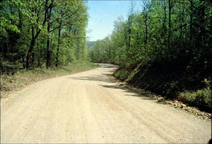
The Military Road—Black’s Ferry Road Segment is eligible for listing in the Arkansas Register of Historic Places under Criterion A with statewide significance as an improved road that follows the original route of the road traversed by the John Benge Detachment in Arkansas during the Cherokee Removal of the late 1830s. The property is being submitted for Arkansas Register recognition under the multiple-property listing “Historic and Archeological Resources Associated with the Cherokee Trail of Tears.”
ELABORATION
The Benge Detachment
The Cherokee removal detachment led by Capt. John Benge consisted of 1,079 people and 70 wagons, though others would join the group as it headed west. The detachment departed from Fort Payne, Ala., in late September and early October 1838. They crossed into Tennessee, then crossed the Mississippi at Iron Banks in Kentucky. Traveling west and southwest through Missouri on the Military Road, the detachment crossed into Arkansas at Hix’s Ferry on the Current River. The Cherokee crossed into Arkansas at a nearby ford to avoid a charge of 50 cents each to transport the people across on the ferry; the crossing probably occurred on Dec. 8, 1838.[i]
The Military Road started in St. Louis and went to St. Genevieve, Missouri, before heading southwest where it crossed Arkansas before heading into Texas and Mexico. Hix’s Ferry had been established around 1800 by William Hix; it was sold a few year’s later to R.P. Pitman, Randolph County’s first county judge.[ii]
Though the Road followed a trail that had been used by travelers for hundreds of years, it became known as the Military Road after Congress approved funds on February 24, 1835, for work on the Road. Lt. R.D.C. Collins approved contracts with Thomas Baker to improve the road as follows: “From Jackson to Elevenpoint, $14.00 per mile; from Elevenpoint to Fourche de Thomas, $18.75 per mile; from Fourche de Thomas to the Missouri state line, $8.50 per mile.”[iii]
The detachment camped at Fourche Dumas on Dec. 9, then headed toward the White River. They most likely traversed the nominated road section on December 10 crossing the Eleven Point River at Black’s Ferry, which had been established around 1815 by David Black, before proceedingto the Spring River and passing by the village of Jackson. They traveled through Smithville on Dec. 12, with one observer noting that “the whole company appeared to be well clothed, and comfortably fixed for traveling.” However, he added, “it is stated that they have the measles and whooping cough among them and there is an average of four deaths per day.”[iv]
The group apparently split north of Batesville on Dec. 15, with some going into Batesville “to get their carriages repaired, horses shod, &c.&c.” while the remainder continued to the west. They rested near Old Athens in Izard County before reuniting and continuing their journey, traveling northwest above the White River toward Talbert’s Ferry.[v] They most likely traversed the surviving sections of the Fort Smith to Jackson Road – Talbert’s Ferry Segments (NR listed, 09/22/04) in late December, 1838.
W.B. Flippen, then about 21 years old, was assisting the ferryman on the White River when the Benge Detachment arrived. He noted that “Many of the Cherokees were well dressed and riding good horses … while the majority, many of them poorly clad. Some of the women having only blankets wrapped around them, several carrying papooses wrapped in a blanket or some kind of cloth and fastened to the backs of their mothers.”[vi]
Flippen recorded the Cherokees’ crossing of the icy White River:
"Instead of their stopping to make terms to cross on the ferryboat, they never pretended to halt but waded across the river, women and men, all except the few who had horses and carriages. They did not pretend to let the women who had papooses ride. It reminded me of a drove of cattle crossing a stream. The river was unusually low at the time, but it was over 200 yards wide. … They camped after crossing the river, built up fires and remained all night."[vii]
The detachment continued west, traveling through Carrollton, Osage, Huntsville and Fayetteville before entering Indian Territory, where the group disbanded on Jan. 17, 1839, having traveled some 768 miles.[viii]
[i] Duane King, “Cherokee Emigration Routes Through Northern Arkansas During the Forced Removal of 1838-1839.” Research report, June 7, 2002, p. 6, 8, 11.
[ii] Lawrence Dalton, History of Randolph County, Arkansas (Little Rock: Democrat Printing and Lithography Co., 1946) p. 16-17.
[iii] Ibid., p. 17-18.
[iv] King, p. 12.
[v] Ibid., p. 12-14.
[vi] Ibid., p. 15.
[vii] Ibid., p. 15.
[viii] Ibid., pp. 17-20.
SIGNIFICANCE
The Military Road—Black’s Ferry Road Segment is eligible for listing in the Arkansas Register of Historic Places under Criterion A with statewide
significance as an improved road that follows the original route of the road traversed by the John Benge Detachment in Arkansas during the Cherokee
Removal of the late 1830s. The property is being submitted for Arkansas Register recognition under the multiple-property listing “Historic and Archeological
Resources Associated with the Cherokee Trail of Tears.”
BIBLIOGRAPHY
Dalton, Lawrence. History of Randolph County, Arkansas (Little Rock: Democrat Printing and Lithography Co., 1946)
King, Duane. “Cherokee Emigration Routes Through Northern Arkansas During the Forced Removal of 1838-1839.” Research report, June 7, 2002.