Listed in Arkansas Register of Historic Places on 08/04/21
STATEMENT OF SIGNIFICANCE
The Macedonia Baptist Church Cemetery is the closest African-American cemetery to the vicinity of Wattensaw. Many burials at Macedonia are unmarked and there are no records of the interred. However, it has been noted through an area history that the Medlock family interred there were part of the late 19th century Arkansas exodus of African-Americans from South Carolina.
The New Hope Cemetery to the west of Macedonia contains one marked burial of a slave, but there is no history on other Wattensaw cemeteries created for the exclusive use of African-Americans.
Due to the need for further research on the interred, Macedonia Baptist Church Cemetery is being nominated to the Arkansas Register under Criterion A, Criteria Consideration D as a remnant resource related to the African-American population of Wattensaw, and a link to the African-American exodus of the late-19th century.
ELABORATION
It is not known when the community of Wattensaw was first settled and officially named, but an 1855 map notes that there was a Wettensas Bayou in the vicinity. By 1878 it was referred to as Wattensaw Bayou. Wattensaw is now located in Lonoke County, but the area was part of Pulaski County at the time of its formation in 1818. Prairie County was formed from Pulaski County in 1846, placing the site of the Wattensaw community in Prairie until the area was re-located to Pulaski in 1869. By 1873 Lonoke County was formed and Wattensaw was situated in its final location within that county.[1]
A look at 1853 and 1854 Bureau of Land Management, General Land Office Maps, does not find much settlement or agricultural activity in the Section, Range and Township, but a local history states that the area eventually experienced growth due to the introduction of the Memphis and Little Rock Railroad. Construction began on the line by 1854. The formation of the Office of Commissioners of State Lands and Immigration was also credited with contributing to this development. By 1856 railroads launched an effort to sell government grant land. In the case of the M and LR line they initially offered land in the vicinity of Wattensaw; however, the road ultimately was laid south of the community in order to run through DeVall’s Bluff. In 1857 it had been partially completed to DeVall’s Bluff from Memphis and was finalized in 1871.[2]
This transportation link was vital to the limited development of Wattensaw because residents were able to travel to and receive goods from Memphis and Little Rock. The larger, incorporated town of Lonoke to the south was accessible via road. By 1882 the population of Wattensaw was between approximately five hundred or six hundred persons, which wasn’t far below the population numbers of Lonoke. An application for a post office in Wattensaw was filed in 1887 and shortly after, the commercial sector began to take shape. This area clustered around the intersection of the current Arkansas Highway 236 and Wattensaw Road. By the 1900s businesses included five general stores, a cotton gin, grist mill, blacksmith, cream station, icehouse, mechanic, and a doctor’s office.[3]
There is no record of a school before the Civil War in Wattensaw. After the war, a log structure for classes and church meetings was built approximately four miles east of the commercial sector circa 1870. The Mason School was built before 1880 on land donated by William Mason immediately to the southwest of that location. The 1880 Brians School was constructed in the same area to the east. So, despite the proximity of Lonoke and the mid-19th century Prairie County (now Lonoke County) seat of Brownsville, Wattensaw was a sizable community.[4]
The primary occupation of Lonoke County’s residents was for-profit and subsistence farming and the principal crop in the late 19th century was cotton. The use of slaves in the county was not unknown, but there were not large numbers of farmers with multiple slaves. Tax assessments of sixteen Wattensaw area families were reported in 1861 to be slaveholders. The lowest number ranged from one slave to the highest of 49 in the household of G.W. Thompson. The 1900 federal census of Wattensaw lists approximately 209 African-Americans (including women and children) living in the community. This would have been in the midst of the era coinciding with the African-American exodus to Arkansas.[5]
The effects of the Civil War on the state resulted in a labor void, which necessitated higher wages and lower rents to attract a workforce. Several groups encouraged freedmen to move to Arkansas. The state’s planters, the Arkansas Freedmen’s Bureau, and the State Bureau of Immigration all circulated information to attract black migrants. Conventions in states to the east of Arkansas involved African-Americans in the process and dispelled fears.[6]
The years between 1870 and 1910 was a period of prolific migration to deep south states by African-Americans from states to the east, and in the 1880s the number of migrants to Arkansas stood at almost sixty thousand. In the mid-1870s the promise of a homestead through federal land grants brought black migrants from Georgia, North Carolina, and South Carolina to Arkansas. The delta region of the state saw the largest numbers of migrants from Georgia. Central Arkansas counties including Lonoke County, witnessed a growth in the black population ranging from 33 to 46 percent in the 1870s. A mass movement from South Carolina to Arkansas was noted in 1881-1882. The North Carolina exodus was the latest and largest segment of African-American movement to Arkansas. By 1899 approximately fifteen thousand African-Americans from North Carolina had dispersed to Arkansas, Mississippi and Texas. Census calculations of African-Americans in Arkansas by 1910 showed a net gain of 105,500.[7]
Land ownership was the primary impetus for migration to the state. This introduced a fresh layer to the former slave’s new state of freedom because they were able to live their lives free of control and exercise their own authority while caring for their families. Arkansas was a prime destination because by 1870 the state had one of the highest rates of southern black land ownership. This was partly due to the fact that Arkansas was still largely undeveloped rough country. Railroad construction fueled the need for labor in Arkansas. Land needed to be cleared to lay tracks, which provided jobs for African-American migrants and helped them establish homes along the lines.[8]
Hazel Hawks wrote in 1986 that G.F. White, John Cook and Joe Gamble of Wattensaw acted as representatives for the migration of black families from Georgia and North and South Carolina to the community. There is no definitive date provided for the families’ arrival other than after the Civil War; however, the 1880 U.S. Federal census places Wattensaw migrant Amanda Medlock in Edgefield, South Carolina. By 1891 a land deed for her husband Walter Medlock notes that he owned 40 acres in Totten Township to the east of Wattensaw beginning in 1885. The last entry for Walter was in 1894. The 1900 U.S. Federal Census of Totten Township lists other African-American families, but further research can be done into which families specifically accompanied the Medlocks.[9]
There is no significant current information on any of the local representatives that brought the families to Wattensaw except John Cook. Cook was the mail contractor for Wattensaw from circa 1882 to 1887. In addition to serving as postal carrier, he owned a general store in Wattensaw. By 1910 Cook was listed as a farmer on the census, married to May Ross (His name was spelled Cooke on the census). Joe Gamble is also listed as a farmer. These facts may account for Cook and Gamble’s part in bringing African-American families to the area, as many were general laborers or tenant farmers. Other Totten township farmers that used tenant labor were Bill Corpier, Tom Mitchell, Frank Brians, and Emmett Jones. In 1900 thirty-six black families made their home in Totten Township. Thirty-five were listed as farmers and twenty-six owned their farms and the remainder rented. One person was listed as a servant.[10]
At the time of the migration phenomenon Lonoke County’s population was majority white, so there were no documented amenities for African-Americans like churches or cemeteries in Wattensaw. In the late 19th century John Cook donated land for the Macedonia Baptist Church for the use of the black families in the area. A brick church was constructed initially. After it was destroyed by fire in 1929 a frame school building known as the Bowers School was moved in from the Bowers farm. At that point it was used as a church and school. In 1954 the Bowers School District was consolidated with the Carlisle School District and the building began to decline. In 1985 it was altered. The church still stands to the southeast of the cemetery on Arkansas Highway 236; however, the roof has sustained damage and the building is overtaken by vegetation to the point of being inaccessible.[11]
When John Cook donated the land for the Macedonia Baptist Church, he also provided land for the Macedonia Baptist Church Cemetery for black families in Wattensaw. The cultural need for this went beyond segregation, although this certainly played a part. African-American cemeteries were significant because it gave them a sense of distinct character that was culturally and socially all their own. Grave offerings provided a link to the deceased from the family and the process of burial and grieving was not dictated by Anglo traditions.[12]
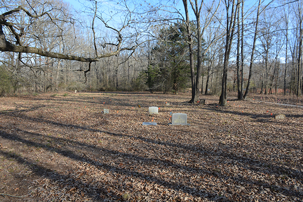
It is suggested that the Macedonia Baptist Church Cemetery site may have been in use prior to its donation by Cook. There are several documented depressions that fix the location of graves, but no burial records that list names for the unmarked graves have been found. Oral history from Wattensaw members of the New Hope Baptist Church suggests that it was originally utilized as a cemetery for slaves, and that its alternate name was New Hope Slave Cemetery. The cemetery exhibits a mix of vernacular concrete forms, illegible funeral home markers and one fraternal-issue form of marble. Items at hand like cinder blocks and the concrete base to a bench are also utilized to mark graves. Some modern graves are marked with ground level slants, upright slant stones, and upright stones of granite. Except for the one historic fraternal-issue marker, commercially produced symbolism is found only on the modern markers.[13]
Some concrete forms that are marked exhibit etched inscriptions. Several like Mandia (Amanda) Medlock’s (B. 1832, D. 1932) concrete stone appears to have been inscribed with stamps. The concrete marker for Dave Cross (B. 1887, D. 1907) and a square shouldered marker with no name, only the inscription “Although he sleeps/ his memory doth/live/and cheering/ comfort/to his mourners/give,” utilized letter stamps. A third concrete stone, that of Mamie Mitchell (B. Unknown, D. Unknown), also displays a stamped inscription.
Exie Graham’s (B. 1902, D. 1969) concrete marker displays metal letters attached to the beveled form. An unusual form is that of Clara Graham’s (B. 1881, D. 1971) square concrete tablet stone. As is tradition, the stone was painted blue at one time, but it also has several items embedded into the concrete. It is not known what the items at the base are, but there is a circular protrusion with “wings” to either side. Above that is what appears to be a metal hook. At the apex of the stone is a metal applique of a bird with wings spread. Three opaque marbles or faux gemstones are placed beneath the bird. The sole historic factory-produced marker is that of Lizzie Ellison (B. unknown, D.1926). It is a fraternal-issue marble upright slant marker provided by the Royal Circle of Friends, Benhill Circle, No. 626.
Other vernacular gravestones consist of an upright square shouldered tablet composed of unfinished stone embedded in a cast metal frame. Elex Graham has been painted on the stone with black paint, but birth and death dates are illegible. A concrete bevel shouldered upright stone exhibits an impressed beveled border and metal disc secured to the concrete at the apex. Faint vestiges of black paint can be seen on this stone.
The community of Wattensaw can still be found on a map, but several changes altered the character of the area, resulting in it becoming a bedroom community for Carlisle, Beebe and Lonoke. The railroad had brought residents to Wattensaw, but the automobile and improved roads began to lure people away. Owners of the stores at Wattensaw began to sell their interests and close their operations. The cotton gin closed in the 1940s. Various merchants came and went up until the 1970s, but the boom years were over prior to that decade. Commercial lots were sold and replaced with homes. Because of new roads it became unnecessary to have numbers of small post offices in rural areas. The Wattensaw Post Office was closed in 1954 and in the 1950s consolidation shuttered the area schools. The agricultural character of Wattensaw remains, but it is less of a community center.[14]
STATEMENT OF SIGNIFICANCE
The Medlock family name is the only documented representative link to the early African-American migrants to Lonoke County and Wattensaw. The names of Graham, Ellison, Mitchell and Cross are recorded there, but it is not known if they traveled with the Medlocks during the southern exodus of the late 19th century. However, the gravestones within the Macedonia Baptist Church Cemetery boundaries provide a thread to the history of the black population of Wattensaw and Lonoke County, and mark it as a remnant resource of that exodus. The social and cultural character of African-American society in 19th century Arkansas is represented by the varied funerary architecture, and the families interred within.
Although there remains more research to be done and the material remains at the Macedonia Baptist Church Cemetery are not numerous, it is still a significant site, providing information for future exploration into the African-American history of Wattensaw and Lonoke County. For these reasons, the Macedonia Baptist Church Cemetery is being nominated to the Arkansas Register of Historic Places under Criterion A, Criteria Consideration D with local significance.
Bibliography
Bureau of Land Management General Land Office Maps. Dependent Resurvey, 985, S3-T3N-R8W. https://glorecords.blm.gov/default.aspx
Cunning, Charles William. “Lonoke (Lonoke County).” Encyclopedia of Arkansas. https://encyclopediaofarkansas.net/entries/lonoke-928/.
“Exodus into Arkansas.” In Race and Ethnicity in Arkansas: New Perspectives. Edited by John A. Kirk. Fayetteville: University of Arkansas Press, 2014.
Goodspeed. “The Goodspeed Historical and Biographical Memoirs of Central Arkansas.” Chicago, Nashville & St. Louis: Goodspeed Publishing Company, 1889.
Hawks, Hazel. “Wattensaw Revisited.” AR: Hazel Hawks, 1986.
Lonoke County Real Estate Tax. 1891. For Walter Medlock.
Matkin-Rawn, Story. “Send Forth More Laborers into the Vineyard: Understanding the African American
_____. “The Great Negro State of the Country: Arkansas’s Reconstruction and the Other Great Migration.” The Arkansas Historical Quarterly, Vol. 72, No. 1. (Spring 2013).
Miller, Sherryl. Lonoke County Museum. Lonoke, AR. Information submitted to AHPP.
Rumsey, David. Map of the State of Arkansas, 1855. New York: J.H. Colton & Co., 1855. https://www.davidrumsey.com.
_____. Map of the State of Arkansas, 1878. Department of the Interior, General Land Office, 1878.
U.S. Census Bureau. Population, 1880. Shaws, Edgefield, SC. From Ancestry.com. www.ancestry.com.
_____. Population, 1910. Totten Township, Lonoke County, AR. From Ancestry.com. www.ancestry.com.
Vlach, Michael. “By the Work of Their Hands: Studies in Afro-American Folklife.” Ann Arbor: University of Michigan Press, 1991.
Wilson, George. Sherwood, AR. Information submitted to AHPP.
[1] Hazel Hawks, “Wattensaw Revisited,” (Self-published), 1986, p. 3; David Rumsey Collection, Map of the State of Arkansas, (New York: J.H. Colton & Co., 1855), https://www.davidrumsey.com, accessed 05/03/21; David Rumsey Collection, Map of the State of Arkansas, (Department of the Interior, General Land office, 1878), https://www.davidrumsey.com, accessed 05/03/21.
[2] Hawks, p. 15-16; Dependent Resurvey, 985, S3-T3N-R8W, Bureau of Land Management General Land Office Maps, https://glorecords.blm.gov/default.aspx, accessed 04/29/21.
[3] Hawks, 2, 39-40, 43, 47; (Hawks states in her book that the commercial section was at the intersection of AR Hwy 236 and Tippett Road, but the modern configuration of Tippett is parallel to 236); Charles William Cunning, “Lonoke (Lonoke County),” Encyclopedia of Arkansas, https://encyclopediaofarkansas.net/entries/lonoke-928/, accessed 05/03/21.
[4] Hawks, 29.
[5] Goodspeed, “The Goodspeed Biographical and Historical Memoirs of Central Arkansas,” (Chicago, Nashville & St. Louis: The Goodspeed Publishing Company, 1889), 585; Hawks, 3, 7-8.
[6] Story Matkin-Rawn, “Send Forth More Laborers into the Vineyard: Understanding the African American Exodus to Arkansas,” in Race and Ethnicity in Arkansas: New Perspectives, John A. Kirk, ed., (Fayetteville: The University of Arkansas Press, 2014), 31, 34.
[7] Ibid, 32, 34, 36, 43; Matkin-Rawn, “’The Great Negro State of the Country’: “Arkansas’s Reconstruction and the Other Great Migration,” The Arkansas Historical Quarterly, Vol. 72, No. 1, (Spring 2013), 3, 25.
[8] Ibid, 12-13.
[9] Hawks, 26; Lonoke County Real Estate Tax 1891, Walter Medlock; U.S. Census Bureau, Population, 1880, Shaws, Edgefield, South Carolina, Enumeration District 061, page 382B.
[10] Ibid, 39; U.S. Census Bureau, Population, 1910, Totten Township, Lonoke County, AR.; Information from Sherryl Miller, Lonoke County Museum, Lonoke, AR, 05/05/21; Hawks, 27.
[11] Matkin-Rawn, “The Great Negro State,” 25; Hawks, 27.
[12] John Michael Vlach, “From Gravestone to Miracle: Traditional Perspective and the Work of William Edmondson,” from By the Work of Their Hands: Studies in Afro-American Folklife, (Virginia: University Press, 1991), 109, 112.
[13] Information submitted by George Wilson, Sherwood, AR, 04/2021.
[14] Hawks, 27, 42, 49.